Eric Gidal and Michael Gavin
Time and Place: Thursday, 01.07., 14:10–14:30, Room 1
Session: Networks and Spatial Analysis
Keywords: GIS; Computational Linguistics; Environmental History; Infrastructure; Urban Networks; Scotland
Our project describes changing relations between language and place in nineteenth-century Scotland, a region that experienced rapid transformation from an agricultural economy to an industrial powerhouse and a central site of a global imperial system. We are interested specifically in the historical geography of these transformations — the alteration of urban centers and rural towns, agricultural and pastoral districts, plantations and planned villages, forests and peat bogs, ports and bays, rivers, lakes, and inlets under the pressures of an extractive economy — and how this geography was recorded by an information infrastructure of print publications and communication networks. By describing Scotland’s economic modernization and ecological changes through these textual records, we aim to produce an environmental geography of print culture in the industrial age. Our research methods therefore combine network modelling with computational linguistics (CL) and geographical information science (GIS) to map the distribution of topics within various bodies of text and across geographical space.
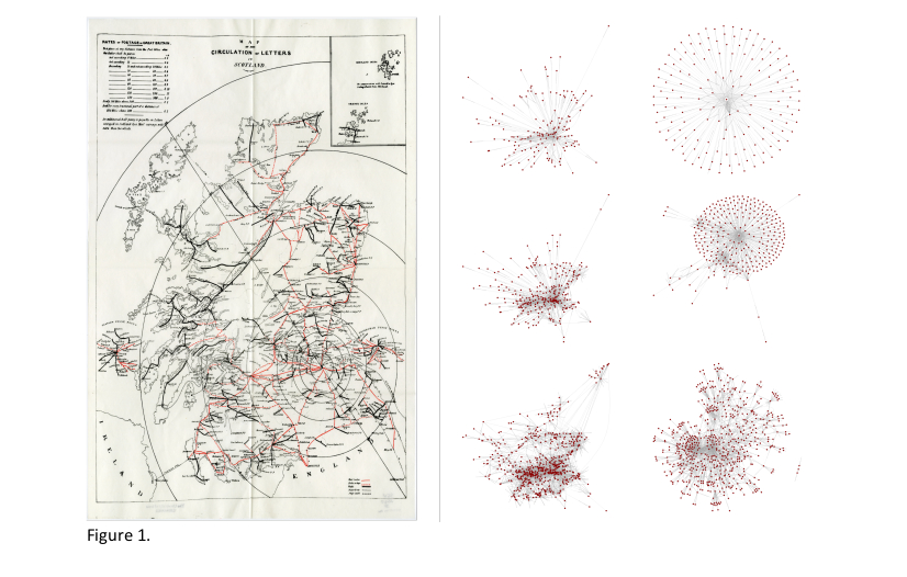
As described in a recent co-authored article, published in the International Journal of Geographical Information Science (Gidal & Gavin 2019), we have built a network model from the collection of postal directories published online by the National Library of Scotland. These directories include detailed data about the daily movements of information (postal routes), capital goods (shipping routes by wagon and boat), and persons (stage-coach routes) and allow us to show how language and geography were conjoined in Scotland’s industrial system. Our model demonstrates what Lynn Hollen Lees refers to as the “space economy” of British industrialization (Lees 2000) — how infrastructural networks increased during this period, transforming Scotland into a cohesive zone of economic and cultural activity. Increasing rates of travel, communication, and shipping through smaller towns caused a qualitative shift in the spatial structure of Scottish infrastructure: as local towns developed into commercial hubs, Scotland’s economy and culture simultaneously decentralised, differentiated, and specialised. In the process, the shape of Scottish networks fundamentally changed from a simple core-periphery structure to an interconnected web of regional hubs.
A map produced by the Parliamentary Committee on Postal Reform in 1838 offers a contemporary visualization of these networks, illustrating the means and routes by which letters were circulated in Scotland. Over the course of the nineteenth century, the geographic reach of the network became substantially wider and denser, with a far greater number of connections beyond Edinburgh and Glasgow. Using centrality measures to clarify the importance of various nodes, we demonstrate how more and more nodes take on the role of local hubs, mediating between the outliers and the major urban centers. Our model represents a kind of hybrid between studies of physical infrastructure and studies of spatially organised social networks (Sarkar et al 2016). Scotland’ s infrastructure transforms from a concentric model that simply divides the centre from the periphery, toward a more complex network of interrelated locales that through their mutual communication constitute Scotland as such.
We use this infrastructure-network model to correlate these changes with a semantic analysis of geographical descriptions contained in the Old and New Statistical Accounts of Scotland (1790s and 1830s-40s respectively), topographical dictionaries and gazetteers, antiquarian and geological surveys, musical miscellanies and literary periodicals. When combined, these datasets allow us to compare changing patterns in geographic description with transformations in the infrastructural networks that supported Scotland’s industrial development. The industrial integration of the varied regions of Scotland and its consequent environmental effects may be traced in the contours of these textual ecologies. We conclude by suggesting that these alignment between textual representation, economic activity, and spatial movement should be viewed as central to nineteenth-century Scotland’s emerging modernity.
Gidal, E. & M. Gavin. 2019. “Infrastructural semantics: postal networks and statistical accounts in Scotland, 1790–1845.” International Journal of Geographical Information Science 33 (12): 2523- 2544. DOI: 10.1080/13658816.2019.1631454
Lees, L.H.. 2000. “Urban Networks.” In The Cambridge Urban History of Britain Volume 3, 1840– 1950, edited by Martin Daunton, 59-94. Cambridge: Cambridge University Press.
Sarkar, D., et al. 2016. “GIScience considerations in spatial social networks.” In Geographic Information Science: 9th International Conference, edited by J.A. Miller, 85-98. Montreal: Springer.