HNR+ResHist2021 is proud to present two keynotes which will be delivered by Marion Maisonobe (CNRS, Paris) and Matteo Valleriani (MPIWG, Berlin). To attend the keynotes, please register for the Conference (deadline: 23 June, 23:30 pm CEST).
Opening Keynote – Wednesday, June 30th, 4:30 p.m. CET
The Sphaera Corpus in its Social and Economic Context
Matteo Valleriani, Maryam Zamani, Malte Vogl, Hassan el-Hajj, Holger Kantz
Download the handout for the conference as PDF: Valleriani_Handout_HNR_ResHist_2021
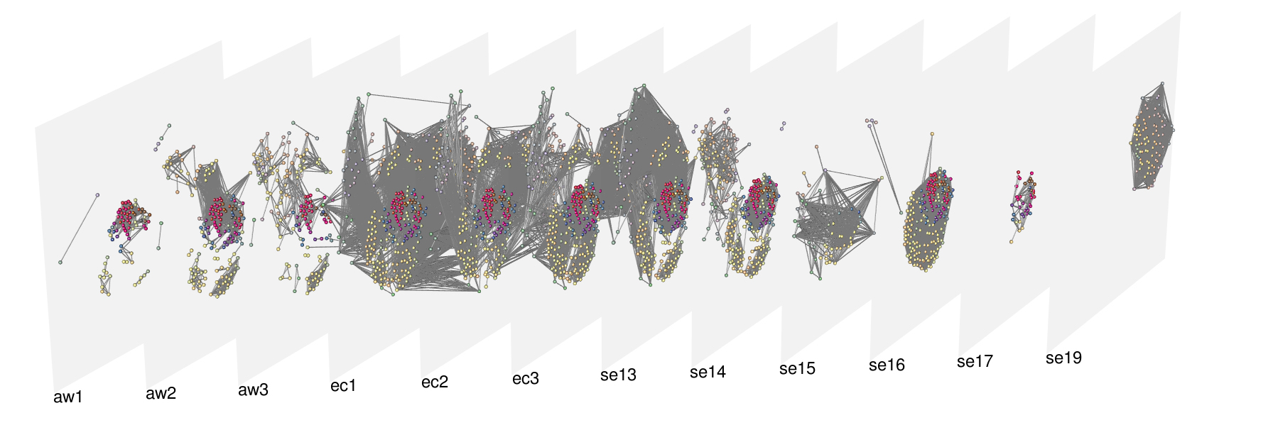
The lecture will first provide an overview of the corpus and of its historical meaning from the perspective of the main research question of the project, namely the question concerned with the mechanisms of knowledge homogenization in the early modern time and, therefore, with those processes that allowed for the emergence of a scientific identity of Europe.
Secondly, the major results concerned with the semantic analysis of the corpus and based on a formalization of the data in terms of a multiplex network will be shown. In particular it will be shown a) how a family of historical sources was detected that then executed a hegemonic role all over Europe therefore greatly contributing to the process of homogenization, b) how treatises, denominated “great transmitters”, allowed for the perpetuation of traditional knowledge for about 200 years however in the context of continuous innovation, and c) how different treatises were identified that are the main responsible for the impactful and enduring innovations.
Third, the lecture will present a new network model able to display the process of knowledge transformation in its social and economic context. The lecture therefore concludes by showing analyses conducted in order to understand correlations between families of treatises (semantic knowledge) on one side and societal groups on the other.
Closing Keynote – Friday, July 2nd, 3:30 p.m. CET
«Les lieux qui font liens»: Several Ways to Integrate Places in Network Analysis
Marion Maisonobe
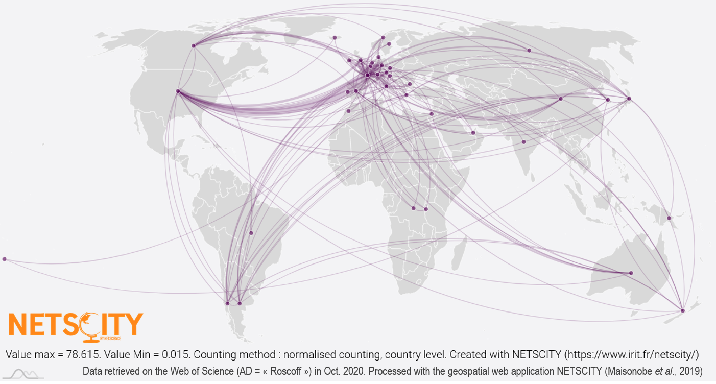
We identify three traditional ways of integrating places in network analysis. Firstly, it is common to start from relationships between individuals, families and businesses and to aggregate these relationships to consider the interactions between places that they create (A). Secondly, places can be the instrument of network construction. In other words, the co-presence in certain places makes it possible to deduce relationships between entities (B). Thirdly, the network can be immediately „spatial“ in the sense that the entities in relation as well as their links are materially anchored in space (for example, a hydrographic network, a metro map or a road network) (C). We will see that the sources, analytical issues and methods, and types of visualisation associated with these different networks vary. Our presentation will focus more specifically on type A and B networks by taking up, detailing and updating the methodological proposals of a collaborative research work on the visualization of scholarly worlds from Antiquity to the present day (Andurand et al., 2015).
Les lieux qui font liens : différentes manières d’intégrer les lieux en analyse de réseau
Nous distinguons trois manières classiques d’intégrer les lieux en analyse de réseaux. Premièrement, il est fréquent de partir de relations entre individus, familles, entreprises et d’agréger ces relations pour considérer les interactions entre lieux qu’elles dessinent (A). Deuxièmement, les lieux peuvent être l’instrument de la construction du réseau. Autrement dit, c’est la co-présence en certains lieux qui permet de déduire des relations entre entités (B). Troisièmement, le réseau peut être immédiatement « spatial » au sens où les entités en relation ainsi que leurs liens sont matériellement ancrés dans l’espace (par exemple, un réseau hydrographique, un plan de métro ou une trame viaire) (C). Nous verrons que les sources, les enjeux et méthodes d’analyse ainsi que les types de visualisation associées à ces différents réseaux varient. Notre exposé se concentrera plus particulièrement sur les réseaux du type A et B en reprenant, détaillant et actualisant les propositions méthodologiques d’un travail de recherche collaboratif sur la visualisation des mondes savants de l’Antiquité à nos jours à partir de différentes sources (Andurand et al., 2015).